Red Tide Effects Will Likely Worsen At Gulf Beaches
- Bryan Bennett
- Jul 17, 2021
- 4 min read

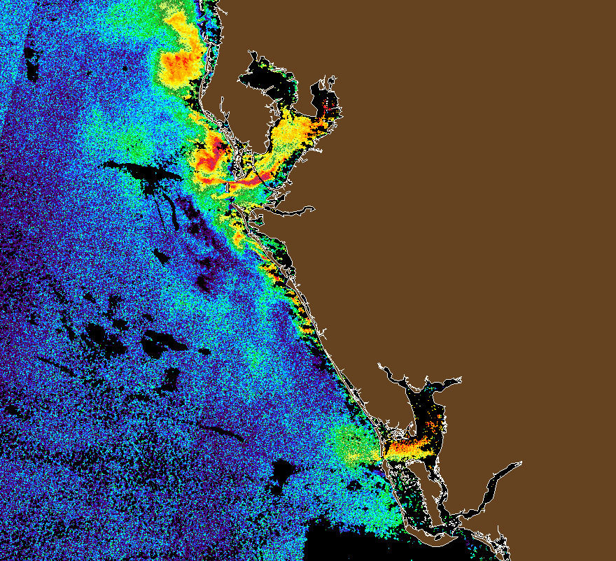
CURRENT STATUS OF RED TIDE: First, I want to make sure that you are able to get the most from the red tide image (above). I create these red tide status updates using a combination of data from brand new satellite technology, surface water samples, and beach/Bay observations.
--Satellite: The imagery is obtained from the European Space Agency's Sentinel line of satellites. The contours on the image are showing Normalized Fluorescence Line Height (NFLH). I have been studying red tide for years and have found this satellite data to provide the most accurate depiction of where red tide is located and its concentration. It detects solar stimulated chlorophyll-a fluorescence, then subtracts radiance data that can contaminate the image. Bottom Line: where you see orange or red, fish are likely dead.

Here's a raw satellite image showing the entire SW coast of Florida. Orange and red colors indicate algae growth that correlates with medium to high levels of karenia brevis (the dinoflagellate that is responsible for red tide in the Gulf). You can see that there is quite a bit of algae growth in the Tampa Bay Estuary and off the coast of Pinellas County. There is also a thin strip of highly concentrated red tide hugging Manatee and Sarasota counties. Data is unfortunately not available for Sanibel and Fort Myers area as a cloud was blocking the satellite's view when it was passing over Florida this afternoon. It is actually fairly difficult to obtain this clear of an image as clouds often obscure the Gulf's view during the stormy days of summer.

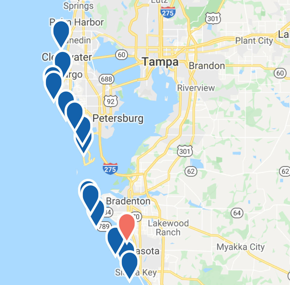
Here's a look at the latest water samples collected by the FWC and associated organizations. The primary bloom is in the Bay and areas just north and south in Pinellas, Manatee, and Sarasota Counties. SW Florida, the Panhandle, and the East coast are not experiencing red tide.

MOTE Marine Laboratory provides a nice network of observations (https://visitbeaches.org/map) located along the west coast of Florida. Many of the sites are updated daily. As of this morning, several sites from Honeymoon Island to Venice were reporting respiratory irritation and dead fish on the beach. Comparatively speaking, the respiratory irritation and dead fish on Gulf beaches is currently fairly minor, but that may change as we head toward next weekend (July 22 and on-wards).
Surface winds can greatly impact red tide's movement. In June red tide was highly concentrated in the southern Tampa Bay estuary, near where the Piney Point phosphate mine dumped over 200 million gallons of untreated water. Along comes Tropical Storm Elsa with a predominantly southeast wind and along with it came the millions of pounds of dead fish washing ashore in St. Petersburg and southern Pinellas.
Winds also have a huge impact on the effects that are felt along Bay and Gulf beaches. An onshore wind brings greater amounts of dead fish and respiratory irritation. Over the past week winds have mainly been out of the east which has continued to exacerbate the stench of dead fish in St. Petersburg and areas in eastern Pinellas.
The predominate wind direction is going to be changing this week. Sunday through Wednesday, winds will mainly be out of the south. Factor in the Ekman Layer and Gulf water currents will be approaching Gulf beaches from the southwest. All you need to know about Ekman Fluid Dynamics is that it is a somewhat complex mix of the Coriolis Effect and pressure gradient forces that result in a slight rightward turn of water currents when compared to the surface winds. I'll factor this effect in when I discuss potential red tide impacts.

Again, winds will turn westerly on Thursday and remain out of the west through next weekend. This means that Gulf beaches will have onshore winds that could bring greater amounts of dead fish near shore. An onshore wind also creates more respiratory distress for beach-goers. Karenia brevis has a thin outer shell that is broken when waves crash ashore. When the shell is broken, it releases a brevetoxin that is responsible for respiratory irritation. BOTTOM LINE: The onshore winds that will be present next weekend (July 22 - July 26) will bring karenia brevis blooms closer to shore and result in larger surf, the result will be additional fish kill & respiratory irritation. On the plus side, downtown St. Petersburg and other easterly facing coasts along the Bay will get a slight reprieve from the amount of dead fish and respiratory irritation.

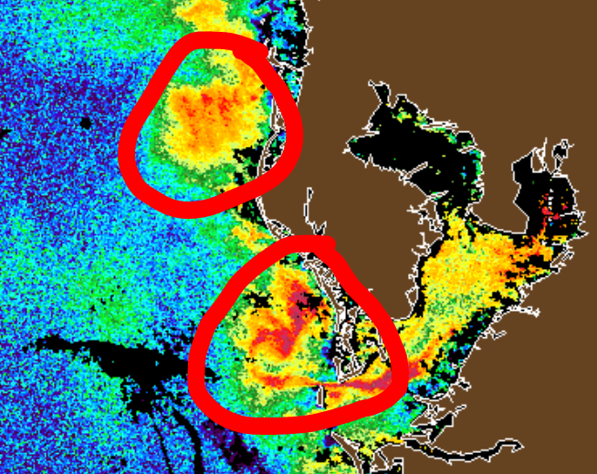
The two twelve mile wide medium to highly concentrated areas of karenia brevis offshore of Pinellas County will likely be noticed when winds shift to the west later this week. A westerly wind will bring these two areas closer to Pinellas beaches and likely contain a greater amount of dead fish than areas adjacent to these blooms.

WHEN WILL THIS ALL END? It's estimated that the Piney Point disaster released the equivalent of 100,000 bags of fertilizer into Tampa Bay. Phosphorus and nitrogen in higher than normal levels is basically a buffet inviting karenia brevis to populate in high numbers. The Bay will have to process all of these nutrients. This red tide event is unprecedented, so it's difficult to draw parallels from past events to determine when the Bay and Gulf waters will regain their health. With favorable weather conditions and a little luck conditions will improve sooner rather than later. Legal action and awareness of the magnitude of this environmental disaster will hopefully deter a repeat occurrence. Being better stewards of the environment will mean that we have a healthy aquatic environment to enjoy for recreation and our livelihoods. Stay tuned to my social media pages and cloudninewx.com for regular red tide updates.

Excellent, science based and balanced content. Thank-you for shining a light on just how disastrous the Piney Point spill has been for our local communitit’s.
Thanks so much for all the information and for being straightforward on how you present it. Thanks too for being honest about the effects of the Piney Point discharge as it gets old hearing comments saying it had no affect.